本研究以自行發展的三維視覺化H.O.S.T(Height-Openness-Slope-Terrain)地圖,評估其在輔助地形判釋的可行性。在地形坡度計算方面,本文採用四種運算方式並分析其差異;在地形開闊度計算方面,本研究針對罩窗半徑、地形對比值、三維視覺化地圖調色盤之設定值做深入的探討。為了解決無高程資訊的問題,本研究納入高程值,並製作立體調色盤。本文研究區域包括多處臺灣特殊地形,吾人將其繪製成三維視覺化地圖來做分析比較,發現自製之三維視覺化地圖對於微地形(沖蝕溝、海溝與沙洲等)之呈現十分明顯,且能提供土砂災害、集水區判定以及地形變遷之良好參考。本研究之最終目的為希望自製三維視覺化地圖能對於後續災害防治、水土保持、環境監測與資源探勘等做出貢獻。
This thesis is aimed at developing self-created three-dimensional visualization H.O.S.T (Height-Openness-Slope-Terrain) maps in order to analyze feasibility of aiding in terrain interpretation. On terrain slope, four methods are adopted and analyzed in this thesis; On terrain openness, we seriously consider the search radius, terrain contrast, and color palette. Furthermore, we create a three-dimensional palette for showing the elevation information on the three-dimensional visualization maps. In this thesis, the study areas include many special terrains in Taiwan, and they are all converted to the H.O.S.T maps. Rigorous analysis and comparisons for these maps are carried out in this thesis. The results show that the three-dimensional visualization maps can better highlight the micro-topographies (gully, trench, sandbank, and so on), and also can provide valuable references for landslide disaster, watershed division and terrain changes. The main purpose of this study is to further bring contributions to the regions of disaster prevention, soil and water conservation, environmental monitoring, and resource exploration.
註:更詳細的資料,請參考H.O.S.T.地圖頁面 (Please check H.O.S.T. map page for more details. )
參考文獻(Reference):
Yokoyama, R., Shirasawa, M., and Pike, R. J. (2002). Visualizing topography by openness: a new application of image processing to digital elevation models, Photogrammetric Engineering and Remote Sensing, 68, pp. 257-265.
Chiba, T., Kaneta, S. I., and Suzuki, Y. (2008). Red relief image map: new visualization method for three dimensional data, The International Archives of the Photogrammetry, Remote Sensing and Spatial Information Sciences, 37, pp. 1071-1076.
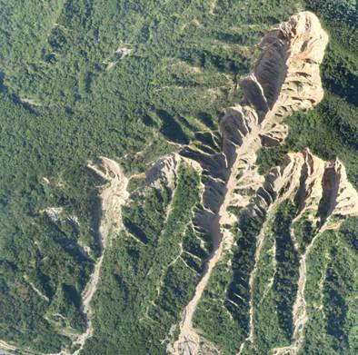 圖1
圖1 火炎山航拍影像。
Figure 1 An aerial photo image on Houyenshan area
|
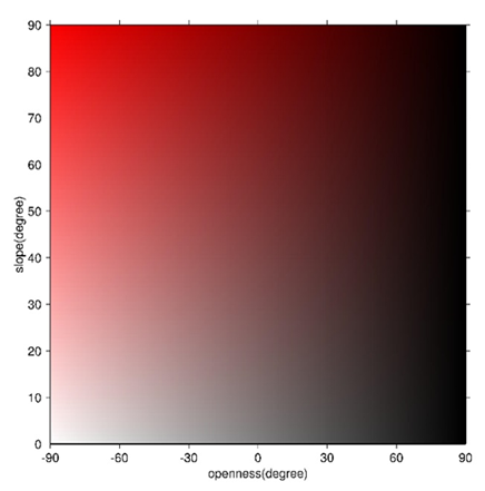 圖2
圖2 自製三維視覺化調色盤(平面)
Figure 2D Palette for creating H.O.S.T map
|
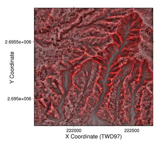 圖3
圖3 自製三維視覺化地圖(利用平面調色盤)
Figure 3 H.O.S.T map on Houyenshan area (use 2D Palette)
|
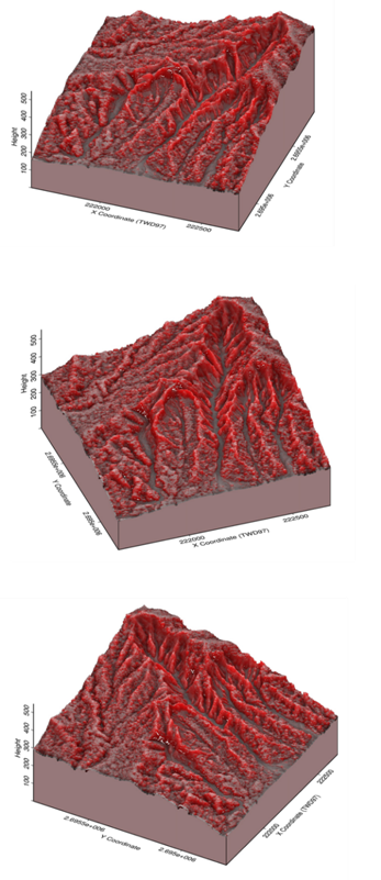 圖4
圖4 自製三維視覺化地圖(立面圖)
Figure 4 H.O.S.T map on Houyenshan area (perspective view)
|
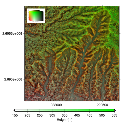
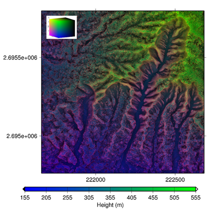 圖5
圖5 自製三維視覺化地圖(利用立體調色盤)
Figure 5 H.O.S.T maps on Houyenshan area (use 3D Palettes)
|
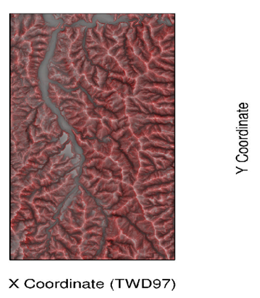
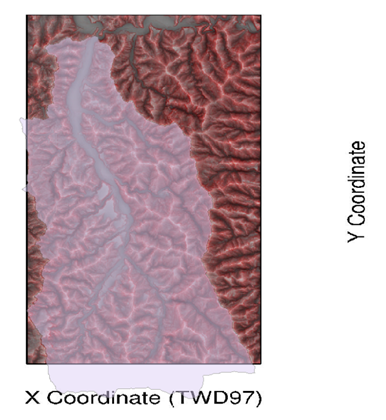 圖6
圖6 自製H.O.S.T地圖與陳有蘭溪集水區套疊結果
Figure 6 The overlapping map of the H.O.S.T and the Chenyoulan river catchment maps
|
臺灣地區多為高山,其地勢陡峭交通不易到達,通常災害發生後,往往因災害發生地區具高危險性,調查分析人員無法深入災區瞭解災害發生情形及進行搶救,於此緊急情況下,為能有效提供即時災情資訊,可利用無人空中載具(Unmanned Aerial Vehicle, UAV)進行拍照或攝影動作,獲取基本圖資,以做出正確決策和災情搶救,無人空中載具除了能即時的蒐集資訊外,更可應用於軍事方面、山坡地監測管理,土砂災害評估、環境保護管理以及河道變遷之監測。
以無人空中載具進行影像空拍,配合高精度之航測控制點,經過航測軟體Pix4Dmapper先利用內建相機初始參數進行率定,再透過影像匹配和空中三角測量,解算匹配後點雲的座標,並進行點雲密集化、三角網格生成等過程,最終可產製彩色3D模型、數值地表模型(Digital Surface Model, DSM)、正射鑲嵌圖、等高線圖與立面影像等成果。另外Pix4Dmapper生成之點雲圖,有全方位旋轉之功能,使我們能夠從不同的視角觀看航拍區域之形貌,還可以自訂航線視角,對整個地形做動態錄影並展示,使展示更加生動。
Taiwan is mostly mountainous, its steep terrains might not be easy to reach in person. When disaster occurs, which normally in highly danger area, investigators could not go deep into disaster area to understand causes and rescue. UAV (Drone) will be a very helpful tool to fly over the unreachable area to capture image or video in case of emergency and provide real time and update disaster information which might help to make adequate decision.
Other than provide real time data, drone could also use in military, slopeland monitoring, sediment disaster evaluation, environmental protection management, river course monitoring.
By use of high precision aerial survey control points, process with Pix4Dmapper, built-in camera initial parameters rating, image matching and aerial triangulation, calculating matching cloud coordinates, processing dense point cloud、triangular grid etc., a colored 3D model、Digital Surface Model(DSM)、Orthophoto mosaic、contour map、stereo photo could be produced. Point cloud produced by Pix4Dmapper is eligible for 360 degree rotation and provide different angle of map viewing. It also allow to customize flight route angle view, real-time recording and showing.
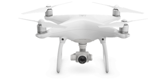 圖1
圖1 大疆(dji)無人空中載具(Unmanned Aerial Vehicle, UAV)。
Figure 1 UAV (Drone)
|
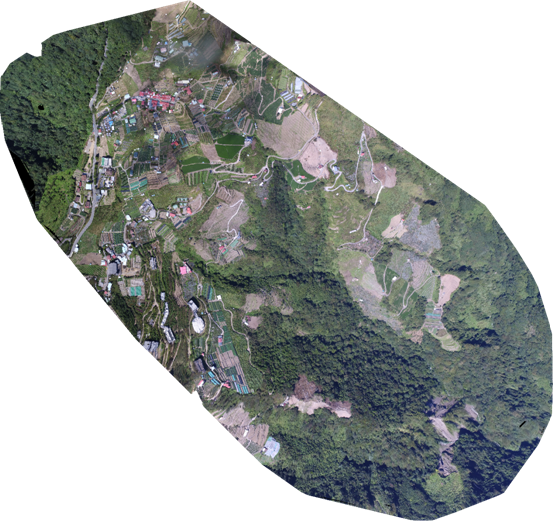 圖2
圖2 南投縣仁愛鄉正射鑲嵌圖。
Figure 2 Orthophoto mosaic for Renai Township, Nantou County
|
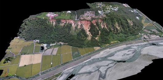 圖3
圖3 臺中市大甲區鐵砧山彩色3D模型。
Figure 3 3D color model for Tieh-Chen mountain in Taichung
|
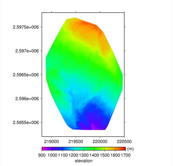 圖4
圖4 嘉義縣阿里山鄉數值地表模型(Digital Surface Model, DSM)。
Figure 4 DSM for Ali mountain in Chiayi
|
隨著國人環保意識的提升,生態檢核為減輕工程對環境的衝擊之重要方法,各工程單位藉由生態檢核可了解所需面臨之生態議題,並與在地民眾以及相關學者專家進行充分的溝通和交流,研擬相關保育對策,最終調整工程之施作使環境保育與工程效益能夠取得平衡。
為有效掌握環境與生態課題,需先彙整計畫工區周邊之生態資源以及潛在的關注物種,資料的彙整包含蒐集轄區內相關生態文獻、透過網站蒐集近期工區範圍內之生態資料,然後進行現場勘查及棲地環境評估。於現場勘查過程中透過民眾參與訪談了解當地的環境、文化及人文等。另外可藉由無人飛行載具(UAV)及相機記錄計畫工程周圍之棲地影像照紀錄繪製環境現況圖與生態關注圖,並於現勘期間填寫生態檢核自評表以及水利工程快速棲地生態評估表以快速了解工區範圍棲地生態狀況,生態議題具體包括重要或特殊棲地、物種與個體、河川縱橫向連結性等。
掌握工區附近的環境特性及生態議題後,於規劃設計前期針對工程設計與工法選擇,依循迴避、縮小、減輕、補償四大原則進行策略考量,提出對環境生態衝擊最小之對策與建議供工程單位參考,以確保將生態的干擾程度降到最低。
With the improvement of people's awareness of environmental protection, ecological check is an important method to reduce the impact of the project on the environment. Engineering units can understand the ecological issues they need to face through the process of ecological check, and conduct full communication and exchanges with the local people, scholars and experts. They can worked out conservation measures, and finally adjust the implementation of the project to achieve a balance between environmental conservation and project benefits.
In order to effectively grasp the environmental and ecological issues, the ecological resources around the project area and potential species of concern need to be aggregated first. The data includes relevant ecological documents in the area under management, and ecological data within the recent industrial area through the website. The on-site survey and environmental appraisal are finally carried out. During the on-site survey, we can understand the local environment, culture and humanities through public interviews. We can also use the unmanned aerial vehicle (UAV) and the camera to record the habitat image around the project to draw the picture of environmental status and ecological sensitivity analysis. In addition, the self-assessment form of ecological check and rapid ecological assessment form for habitats of hydraulic engineering can be completed during the on-site survey to quickly understand the ecological status of habitats in the work area, ecological issues include important or special habitats, species and individuals, and the vertical and horizontal connectivity of rivers, etc.
After grasping the environmental characteristics and ecological issues near the work area, the design and engineering methods at the early stage follows four major principlesavoidance, reduction, mitigation, and compensation. We can propose countermeasures and suggestions of minimizing environmental and ecological impact to the engineering units in order to ensure that ecological disturbance is minimized.
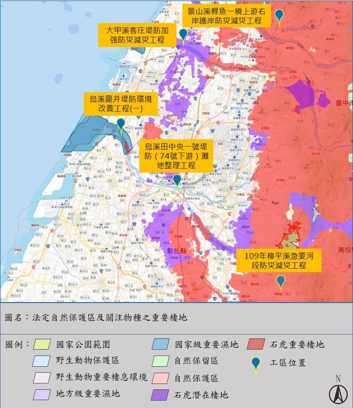 法訂自然保護區及關注物種之重要棲地
Obligate nature reserve & Important habitat of Concerned species
|
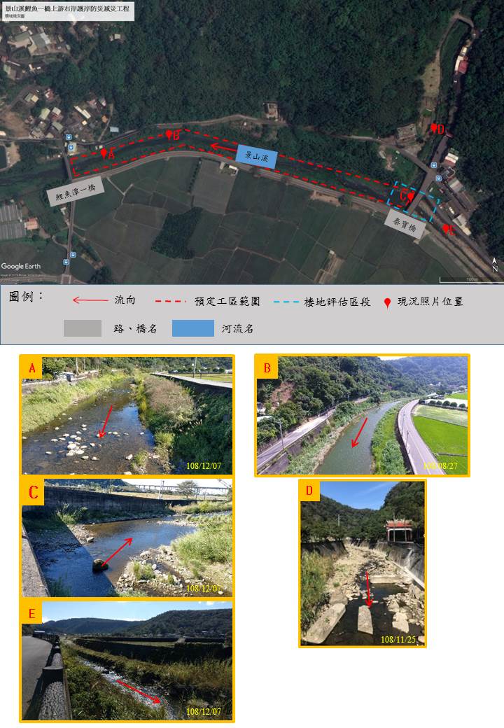 環境現況圖
環境現況圖
picture of environmental status
|
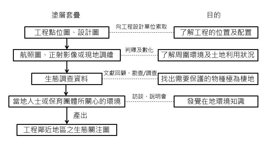 生態關注圖繪製流程圖
Flow chart of drawing ecological sensitivity analysis
|
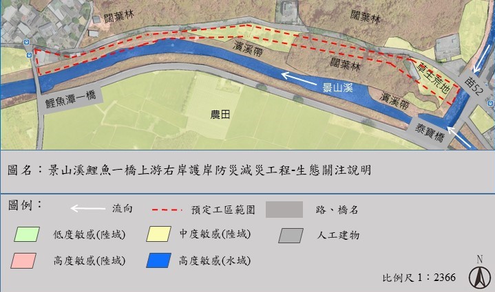 生態關注圖
生態關注圖
Ecological sensitivity analysis
|
本研究利用重力測量與地電阻觀測技術,配合地下水井時水位資料,求定名竹盆地含水層之比出水率值。本團隊於2016年9月至2017年9月間,已在研究地區進行5次重力測量與地電阻聯合施測。重力測量的部分,利用絕對重力儀FG5於新民村辦公室、社寮國中、新民地下水井等測站進行重力測量;地電阻觀測的部分,於濁水溪北岸拉設數條測線,以獲取測區地下水位之位置。除此之外,本團隊於2017年6月於新民地下水井測站旁,進行一抽水試驗,用以輔助與佐證相關研究。本研究期望藉由比出水率計算成果,來推估名竹盆地地下水資源,並對未來名竹盆地地下水庫開發作出貢獻。
We combine gravity, electrical resistivity tomography (ERT), and groundwater well data to estimate the specific yields in Minzhu Basin. Five joint surveying missions combing gravimetry and ERT were im-plemented in Minzhu Basin from September 2016 to September 2017. On the field surveys of gravime-try, we used the absolute gravimeter FG5 to collect the gravity observations at the stations of Xinmin village office, Sheliao junior high school, and Xinmin groundwater well; on the field surveys of ERT, we laid the surveying profiles on northern side of Zhuoshuixi River to collect the ERT observations. In addition, we did a well pumping test near Xinmin groundwater well in June 2017 to assist in supporting research. This study is to estimate the groundwater resources in Minzhu Basin with the results of the specific yields. We expect the results can further bring contributions for the development of under-ground reservoirs in the area.
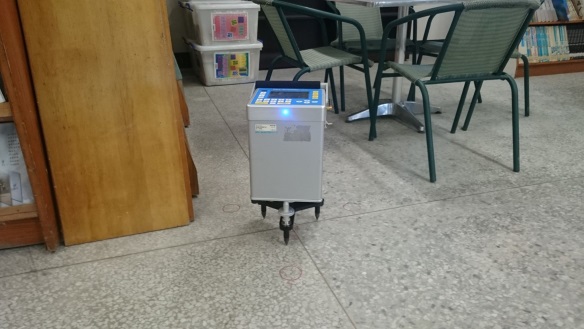 圖1
圖1 CG5 相對重力儀
Figure 1 Ralative gravimeter CG5
|
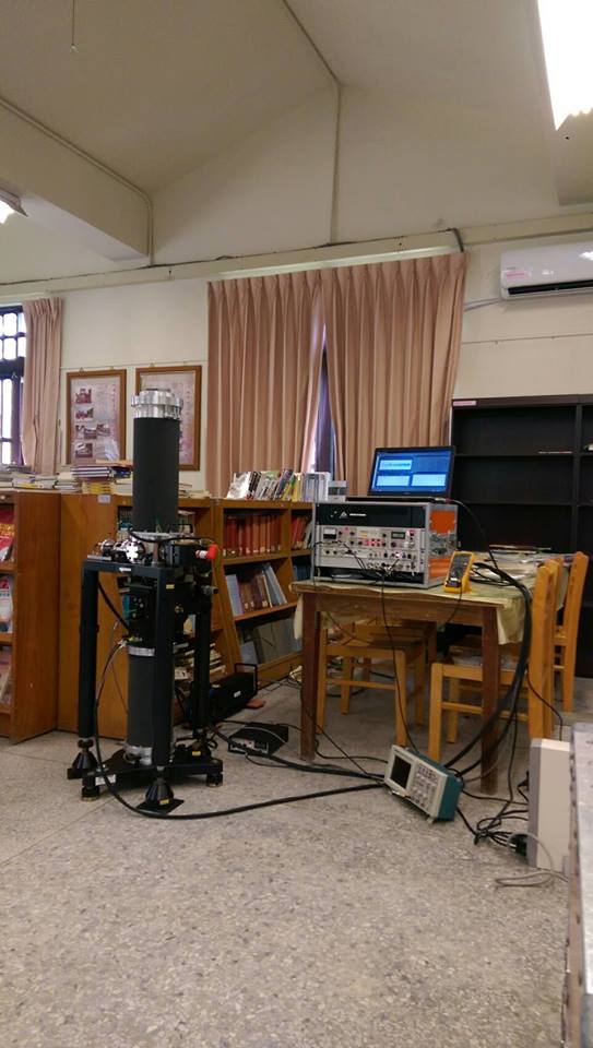 圖2
圖2 FG5 絕對重力儀
Figure 2 Absolute gravimeter FG5
|
|